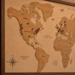
Travel maps with pins are visual tools that let travelers mark destinations, routes, and experiences on a physical or digital map using colored pins, flags, or markers.
They help you plan trips, track places visited, organize multi-stop itineraries, and share your travel story with others all at a glance.
There is something deeply satisfying about pushing a pin into a map. It is a small act, but it means something big you were there. Or you are going. Or you are dreaming.
Travel maps with pins have helped explorers, road-trippers, and weekend wanderers organize their journeys for generations, and today they are more powerful than ever.
If you are planning a cross-country road trip through the American Southwest, tracking every national park you have visited, or building a dream bucket list of places you want to see before you die, a travel map with pins gives your adventures a shape.
It turns scattered memories and future plans into something you can see, share, and celebrate.
This guide covers everything you need to know about travel maps with pins from choosing the right type of map to using digital tools, avoiding common mistakes, and turning your map into a genuine piece of wall art. By the end, you will know exactly how to set up and use a travel map that actually works for your style of travel.
What Are Travel Maps with Pins and Why Do Travelers Love Them?
A travel map with pins is any map printed, framed, cork-backed, or digital where you use markers to indicate places you have been, plan to go, or want to remember. They serve as a living travel diary and a planning tool at the same time.
Travelers love them for three reasons. First, they offer instant visual clarity you can see at a glance If your road trip covers too much ground or your bucket list leans heavily toward Europe. Second, they create a sense of accomplishment. Placing a pin after a hard-earned adventure is genuinely rewarding. Third, they spark conversations. A pinned map on your wall is the most reliable party icebreaker in existence.
According to a 2023 consumer travel survey by Skift Research, over 68% of frequent U.S. travelers use some form of visual trip-planning tool, If physical or digital. Travel maps with pins rank among the most popular options.
Types of Travel Maps with Pins: Which One Is Right for You?
The right type of map depends on how you travel, how much wall space you have, and If you prefer physical or digital tools. Most travelers eventually use both.
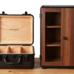
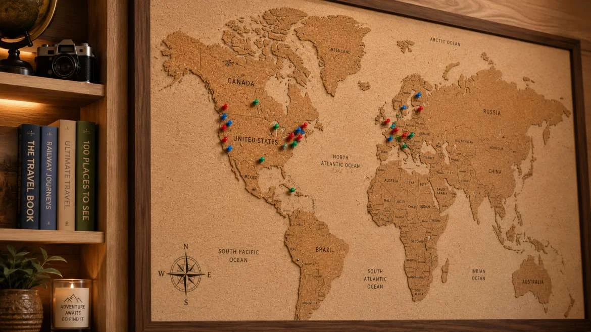
Push-pin cork maps are the classic choice. They mount on a wall like a picture frame, and you physically press color-coded pins into destinations. They range from small 12×8-inch desk versions to large 36×24-inch wall pieces. Popular among home decorators and serious travelers alike, cork maps double as art.
Scratch-off maps let you reveal color underneath a foil layer as you visit new places. They are especially popular as gifts and work well for travelers motivated by the visual reward of uncovering new territory.
Digital pin maps use apps or web platforms like Google My Maps, Furkot, or Wanderlog to drop virtual pins with notes, photos, links, and routes. These are ideal for active trip planning and sharing itineraries with travel companions.
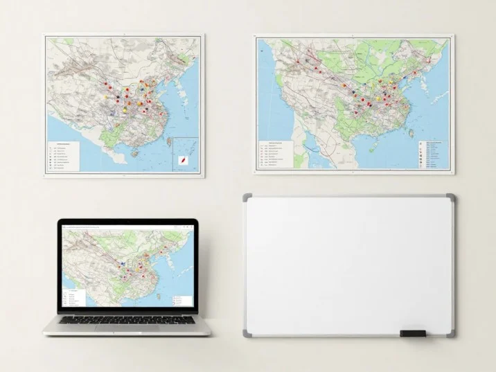
Magnetic dry-erase maps work well for families and frequent travelers who want to rearrange plans without committing to permanent holes. They are easy to update and wipe clean between trips.
| Map Type | Best For | Price Range | Durability |
| Push-pin cork map | Home display, long-term tracking | $20–$80 | High |
| Scratch-off map | Gift, casual tracking | $15–$40 | Medium |
| Digital pin map | Active planning, sharing | Free–$15/mo | N/A |
| Magnetic dry-erase | Families, frequent updates | $30–$70 | High |
| Framed paper map | Decoration, gift | $25–$100 | High |
Best Digital Travel Map Tools with Pin Features

Digital travel maps have evolved dramatically in the last five years. The best tools let you drop pins, add notes and photos, build routes, and share your map with co-travelers all from your phone or laptop.
Google My Maps remains the gold standard for free digital pin mapping. You can create custom layers, color-code pins by category (restaurants, hotels, attractions), add descriptions, and share a link with anyone. It syncs directly with Google Maps for navigation, which makes it practical for on-the-ground use.
Wanderlog is purpose-built for trip planning. It combines a pin map with an itinerary builder, budget tracker, and packing list. It pulls in reviews from Google and TripAdvisor directly into your map pins, which saves research time. The free plan covers most travelers’ needs.
Furkot specializes in road trip planning. You enter your starting point, destinations, and daily driving limit, and Furkot automatically builds a logical route. Pins include stop details, campground options, and estimated driving times especially useful for long-haul drives along routes like Route 66 or the Pacific Coast Highway.
Felt is a newer mapping tool designed for collaborative use. Multiple people can add and edit pins simultaneously, which makes it a strong choice for group travel planning.
Polarsteps automatically tracks your location as you travel and drops pins in real time. You can add journal entries and photos to each pin, creating a living travel log that doubles as a shareable trip diary.
How to Set Up a Physical Travel Map with Pins at Home
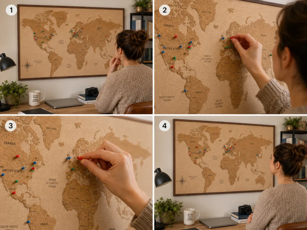
Setting up a wall map with pins takes about 30 minutes and produces something you will look at every day. Follow these steps for a setup that holds up over time.
First, choose your map size based on your wall space and travel scope. A U.S.-only map works well in a 24×16-inch format. A world map benefits from at least 36×24 inches to keep country labels readable. Second, mount the map before adding pins. If using a cork-backed frame, hang it with two wall anchors rated for at least 10 pounds to prevent sagging.
Third, plan your pin color system before you start. A common system uses red pins for places visited, green for places planned, and yellow for bucket-list dreams. Blue works well for places where you have family or friends. Write a small legend on a card and tack it to the bottom corner of the frame. Fourth, use flat-head or ball-head pins rather than standard sewing pins they are easier to press in and remove without tearing the map surface. Fifth, group destination pins for cities rather than trying to pin every neighborhood. One pin per city keeps the map readable.
Insider tip: Place your map at eye level in a room where guests gather. Maps hung in entryways or living rooms generate more conversation and give you more reasons to update them regularly.
How to Use Google My Maps for Trip Planning with Pins
Google My Maps is free, powerful, and already synced with the navigation app most travelers use daily. Here is how to get the most out of it.
Start by going to mymaps.google.com and clicking “Create a New Map.” Name your map by trip or year “Pacific Northwest Road Trip 2025” or “National Parks Bucket List” works well. Create separate layers for different categories: one layer for lodging, one for restaurants, one for attractions, and one for gas stops on long drives. Each layer can have its own pin color and icon style.
To add a pin, search for a location in the search bar and click “Add to map.” Fill in the description field with notes: confirmation numbers, reservation times, must-order dishes, or trail difficulty ratings. You can also attach photos directly to pins.
Share the map with travel companions by clicking the share button and choosing “Anyone with the link can view” or “can edit” for collaborative trips. The shared map stays live and updates automatically when anyone makes changes, which eliminates the need for group text threads to coordinate plans.
Time-saving tip: Import a spreadsheet of destinations directly into Google My Maps using the import function. If you have a list of 20 national parks in a CSV file, you can pin all of them in under two minutes rather than searching one by one.
Travel Maps with Pins for Road Trips Across America
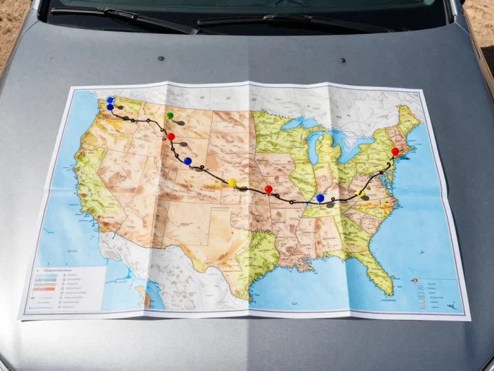
Road trips are where pin maps truly earn their place. A well-pinned route transforms a vague “drive across the country” plan into a structured adventure with clear waypoints, backup options, and realistic daily distances.
For planning a U.S. road trip, start by dropping pins on your must-see destinations first, then fill in logical stopping points between them. Tools like Furkot and Google My Maps both show driving distances between pins automatically, which helps you avoid the classic mistake of underestimating how long it takes to drive across states like Texas or Montana.
Color-code your pins by priority. Red for non-negotiable stops, orange for strong maybes, and gray for backup options if weather or timing shifts. This system lets you adapt on the fly without losing sight of your core plan.
Some of the most pin-worthy U.S. road trip routes include the Pacific Coast Highway along California’s Highway 1, the Blue Ridge Parkway stretching 469 miles through Virginia and North Carolina, the Going-to-the-Sun Road in Glacier National Park, and the full stretch of Route 66 from Chicago to Santa Monica. Each of these routes has dozens of natural stopping points that reward careful pin placement.
Hidden gem stop on Route 66: Most travelers pin the big towns Amarillo, Albuquerque, Flagstaff. Fewer stop at Palo Duro Canyon State Park in Texas, often called the “Grand Canyon of Texas,” which sits just 15 miles off Route 66 near Amarillo and sees far fewer crowds than the main attractions.
National Park Travel Maps: Tracking All 63 Parks with Pins
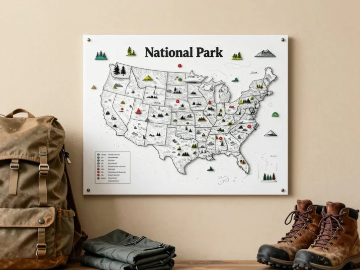
For National Park enthusiasts, a dedicated pin map is practically a rite of passage. The U.S. National Park System includes 63 designated national parks spread across 30 states, plus hundreds of monuments, seashores, and recreation areas managed by the National Park Service (NPS).
The NPS itself offers printable passport stamp maps at many visitor centers, but dedicated pin maps go further. Several companies produce national-park-specific wall maps with illustrated park icons and space for pins or stickers at each location. These make strong gifts for hikers, campers, and outdoor families.
When tracking national parks with pins, consider adding a second pin or a small tag to note the year visited. Looking back at a map and seeing that you visited Zion in 2018 and Grand Teton in 2022 adds a timeline dimension that a single pin cannot capture.
Underrated alternative to the famous parks: Instead of pinning only the “big five” Yellowstone, Grand Canyon, Yosemite, Zion, and Great Smoky Mountains consider adding pins for less-visited gems like Great Basin National Park in Nevada, Guadalupe Mountains National Park in west Texas, or Congaree National Park in South Carolina. All three receive fewer than 500,000 visitors annually compared to Yellowstone’s 4+ million.
Travel Pin Maps as Gifts: What to Know Before You Buy
Travel maps with pins have become one of the most reliable gifts for travelers, remote workers with wanderlust, and anyone who has ever said “I want to see the world.” But not all travel map gifts are equal.
Before buying, consider three things. First, know the recipient’s travel scope. A U.S.-focused traveler will get more use from a detailed U.S. state map than a world map with tiny country details. Second, check the backing. Cork-backed maps are the most pin-friendly and the most durable. Maps printed on paper without a backing tear easily and do not accept pins without a separate mounting solution. Third, look at frame quality. Cheap plastic frames warp over time, especially in humid environments. Solid wood frames hold better.
Top-rated options in the $30–$80 range typically include the map, a set of 100–200 color-coded pins, a mounting kit, and a small legend card. Personalized maps with a custom title “The Smith Family Adventures” add a meaningful touch and are widely available through Etsy sellers and dedicated map retailers.
Money-saving tip: Buy the frame and map print separately rather than as a bundled set. A high-quality 24×36-inch poster-size map print costs $10–$20, and a matching frame from a home goods store costs $20–$40. The total is often cheaper than a “premium” bundled product, and you get better quality control over both components.
Common Mistakes Travelers Make with Pin Maps (and How to Fix Them)
Even enthusiastic travelers make a few predictable errors when setting up and using travel maps with pins. Knowing them in advance saves time and frustration.
Mistake 1: Pinning too many places in one area.
When pins cluster heavily in, say, New York City or the California coast, the map looks cluttered and the visual story gets lost. The fix is to pin at the city or region level rather than the neighborhood level. One pin for “San Francisco” tells the story as clearly as five pins for specific neighborhoods.
Mistake 2: Not creating a legend.
A map with 200 random pins is beautiful but confusing to anyone (including your future self) who looks at it six months later. Spend five minutes writing out your color system on a small card and attaching it to the frame. It transforms a decorative piece into an actual navigational story.
Mistake 3: Using a map that is too small for the detail needed.
A world map smaller than 24×18 inches compresses countries in Asia and Africa to nearly unreadable sizes, making it impossible to pin accurately. Measure your wall space before buying, and err toward larger rather than smaller.
How Travelers Use Pin Maps to Plan Future Trips
A travel map with pins is not just a record of where you have been it is one of the best planning tools available for future trips. The visual layout reveals gaps, patterns, and opportunities that a spreadsheet or list simply cannot show.
Many travelers divide their pins into “visited” and “want to visit” categories and then look for geographic clustering. If your bucket-list pins cluster heavily in the Mountain West Colorado, Utah, Wyoming that is a signal to plan a multi-week regional road trip rather than several separate flights. The map essentially does the trip-planning math for you.
Travel bloggers and frequent travelers also use pin maps as a prioritization tool. When you can see all your “want to visit” pins at once, you naturally start to rank them. The pins in regions you have already partially explored feel more achievable. The isolated pins in distant corners of the map start to feel like long-haul adventures worth saving for.
Insider tip: Take an annual photo of your pin map each January. Watching the map fill over years is genuinely motivating and gives you a record of your travel pace and patterns that no app perfectly replicates.
Digital vs. Physical Travel Maps with Pins: Which Should You Use?
Most experienced travelers use both, but understanding the strengths of each helps you decide where to invest your time and money.
Physical pin maps win on display, emotional reward, and conversation value. There is no digital equivalent to pointing at a wall and saying “I have been to all of those.” They work without an internet connection and do not require software updates. The tactile satisfaction of pressing a pin into a destination you just returned from is something no app replicates.
Digital pin maps win on practicality and flexibility. You can update them in real time from your phone, share them instantly with travel companions, attach unlimited photos and notes to each pin, and access them anywhere. For active trip planning, digital tools are simply more efficient.
The ideal setup for most travelers is a physical map for the home wall tracking completed adventures and displaying the overall journey paired with a digital tool like Google My Maps or Wanderlog for active planning. The two systems serve different needs and reinforce each other well.
Best Photo Spots to Document Your Pinned Destinations
Half the value of pinning a destination is capturing a great photo that makes the pin worth placing. Knowing the best photography spots in advance saves time and produces better results.
For national parks, the NPS website lists suggested scenic viewpoints for most parks. Sunrise and sunset are the highest-value times at rocky and canyon landscapes Bryce Canyon’s amphitheater at sunrise, for example, produces colors that midday simply cannot match. The NPS recommends arriving at popular overlooks 30–45 minutes before sunrise to secure a good position.
For city destinations, local Instagram geotags often surface the most photogenic spots faster than any guidebook. Search the city name as a location tag and sort by “top posts” to identify the spots that consistently produce strong images.
For road trip stops, pull over at state welcome signs every state has one, they are free, quick, and make your travel photos immediately recognizable and shareable.
Best photo tip: After pinning a destination on your physical map, write the coordinates or a brief location note on the back of a small card and slip it into the frame. It creates a personal index of your best photo spots that you can reference on return visits.
Responsible Travel and Pin Map Ethics
As pin maps grow in popularity especially on social media where “pin map walls” generate significant engagement it is worth pausing on a few responsible travel considerations.
Publicly sharing detailed pin maps of remote natural areas, off-the-beaten-path destinations, or Indigenous cultural sites can contribute to overtourism at fragile locations. Several wilderness areas and cultural sites in the U.S. have seen significant environmental and cultural damage from social-media-driven visitor spikes. The Leave No Trace Center for Outdoor Ethics recommends using general region-level location tags rather than precise GPS coordinates when sharing sensitive outdoor destinations publicly.
For travel within Native American lands or near protected cultural sites, check with the relevant tribal nations or land management agencies before visiting or sharing locations publicly. Many tribal tourism programs, including those managed through the American Indian Tourism Association, welcome respectful visitors but ask that visitors follow specific protocols regarding photography and sharing.
Pin your adventures freely and share your map proudly just be thoughtful about which pins you broadcast to large audiences.
FAQ:
What is the best travel map with pins for home display?
The best home display maps combine a detailed, accurate map print with a sturdy cork backing and a solid wood frame. Look for maps at least 24×18 inches for a U.S. map or 36×24 inches for a world map. Sets that include 100+ color-coded pins and a mounting kit offer the best value. Prices range from $30 to $80 for quality options.
Can I use Google Maps to create a custom pin map?
Yes. Google My Maps (mymaps.google.com) is a free tool that lets you create fully custom pin maps with color-coded markers, written notes, photos, and shareable links. It is different from standard Google Maps and is specifically designed for custom mapping projects.
How many pins do I need for a travel map?
A starter set of 100 pins handles most travelers’ needs for the first few years. If you travel frequently or plan to pin at a granular level, sets of 200–500 pins are available cheaply online. Color variety matters more than sheer quantity aim for at least four distinct colors to support a useful legend system.
What is the difference between a scratch-off map and a push-pin map?
A scratch-off map has a metallic foil layer over each country or state that you scratch off after visiting, revealing color beneath. A push-pin map uses a cork backing where you press physical pins into destinations. Scratch-off maps offer a visual reveal reward but cannot be undone if you scratch incorrectly. Push-pin maps are more flexible and more durable long-term.
Are travel maps with pins good gifts?
Travel maps with pins consistently rank among the most appreciated gifts for travelers. They are personal, visually appealing, and long-lasting. For the best reception, match the map scope to the recipient’s travel habits a dedicated U.S. traveler will appreciate a detailed state map more than a world map.
How do I prevent push pins from falling out of my travel map?
Use flat-head or ball-head push pins rather than standard sewing pins they grip better in cork. If your map uses a thin cork layer, add a secondary thin cork sheet between the map and the frame backing for extra grip depth. Keep the map away from high-traffic areas where it might get bumped regularly.
What is the best app for creating a digital pin map for a road trip?
For road trips specifically, Furkot is the strongest option because it automatically builds logical routes based on your stops and daily driving limits. Google My Maps is the best free all-purpose option. Wanderlog works best when you want to combine pin mapping with itinerary building, budget tracking, and restaurant research in one place.
Conclusion
Travel maps with pins turn your journeys into something you can see, share, and build on.
Three things make them worth your investment: they bring visual clarity to your trip planning, they create a lasting record of your adventures, and they keep the motivation to explore alive every time you walk past them.
If you mount a cork-backed world map on your living room wall, build a detailed digital map in Google My Maps for your next road trip, or gift a scratch-off map to someone who is just beginning to explore, the act of placing a pin real or virtual connects you to the places that matter.
Start with the destinations you have already visited. The blank spaces on the map will take care of the rest.

Ben Fogle believes that true adventure begins where the pavement ends. After spending years documenting extreme environments, rowing across oceans, and trekking through frozen landscapes, he mastered the art of wilderness travel. For Travelmarse, Ben constructs highly detailed guides on deep-nature packing lists, wildlife safety, and sustainable eco-tourism. He breaks down intimidating, rugged expeditions into clear, step-by-step roadmaps so everyday travelers can safely connect with the natural world.